|
Three small contrasting villages in the Garrigues,
approximately an hour's drive from Barcelona, form the basis for an
investigation into the economic, social and environmental impact of rural
depopulation in the region. The impact of depopulation in some of the villages
is evident in the loss of services, the number of abandoned fields and
gentrified second homes. Some villages have suffered more than others, and
primary data collection seeks to identify the range of factors responsible.
 |
|
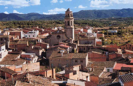
L'Albi - a typical village in the Garrigues region
|
The Garrigues region comprises a plateau inclined towards the
northwest, bordered to the south by the Catalan Central Depression and to the
north by the Urgell plain. The Set is the most important river draining the
region where the average annual rainfall is 482 mm, falling in only 47 days of
the year, mainly in autumn and spring. The climate is continental Mediterranean,
with the altitude and distance from the sea causing a significant lowering of
winter temperatures.
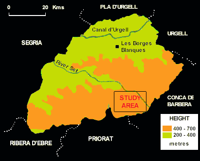 |
| Les Garrigues: Relief |
The soils are dry and rocky, predominantly lime, with pHs of
8.0 - 8.5. The typical soil profiles on the slopes have little or no B horizon
development. The extensive cultivation of the Arbiquina Olive, ideally suited to
these climatic and soil conditions, is the most characteristic crop of the
region. It is hand-picked and produces a high quality oil, mainly for export.
Almonds are also grown in the unirrigated areas, together with vines in the
damper clay valleys. The lower land to the north of the region is irrigated and
here wheat, corn, beans and sunflowers are cultivated.
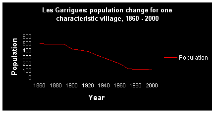
The population in the region reached its maximum in the middle
of the nineteenth century and rural depopulation has been a common feature since
1860, accelerating in the 1960s. The typical population change in the region is
illustrated in the chart below for one characteristic village:
Accessibility to markets is not a causal factor in rural
depopulation in Les Garrigues as is most often the case in other rural areas.
The average distances and travel times to the main towns and cities in the area
are shown below:
|
Accessibility in kilometres and time to the main markets |
|
Kilometres |
Time (min) |
| Barcelona |
125 |
75 |
| Lleida |
41 |
40 |
| Tarragona |
52 |
55 |
| Borges Blanques |
18 |
15 |
| Montblanc |
16 |
15 |
The environmental effects of land abandonment can be extended
through the use of Rothermel's (1972) model that uses 13 descriptive vegetation
units as a guide to the biomass production of combustible material. This can be
applied to the development of a fire-hazard risk assessment for the abandoned
fields.
Relationships explored can include the link between the
steepness of the slopes in an area and the number of abandoned fields.
Statistical techniques can include a slope steepness index, Spearman's Rank
Correlation Coefficient and Chi-squared.
There is a wealth of secondary data available to assist the
detailed analysis of the socio-economic processes leading to depopulation in the
region.
Ecosystem work may be integrated into the investigation,
studying maquis vegetation recolonisation and soil erosion in four 20 metre
plots: two abandoned 30 years ago, one in a shaded site, the other sunny, and
the other two abandoned fifteen years ago, also in sunny and shaded sites
respectively. Other factors, e.g. slope angle and height are controlled.
Students may use GPS to locate the abandoned fields if desired.
|