|
Rock Creek Canal near Darby, Montana - n = 0.060 (Source: U.S.G.S Water
Supply Paper 1849)
Site Description
- Station name
| Rock Creek Canal, near Darby, Montana |
- Station number
|
12-2455 |
- Gauge location
|
Lat 46°04'40'', long 120°28'30'', in SW 1/4 sec. 28, T. 4 N., R. 21 W., on
downstream side of footbridge, 0.25 mile downstream from diversion dam, 1.5
miles downstream from Como Lake, and 4 miles northwest of Darby. Section 1 is
about 0.25 mile upstream from gauge. |
- Date of flood
|
September 23rd, 1948 |
- Gauge height
|
3.34 ft at gauge; 15.33 ft at section 1 |
- Peak discharge
|
138 cfs |
- Computed roughness coefficient
|
Manning n = 0.060 |
- Description of channel
|
Bed and bank consist of boulders ; d50 = 210 mm, d84
= 375 mm. |
|
Reach Properties
| Section |
Area (sq ft) |
Top Width (ft.) |
Mean depth (ft) |
Hydraulic radius (ft) |
Mean velocity (ft
per sec) |
Length (ft) between sections |
Fall (ft) between sections |
| 1 |
30 |
26 |
1.15 |
1.07 |
4.60 |
....... |
..... |
| 2 |
31 |
25 |
1.24 |
1.19 |
4.45 |
45 |
1.25 |
| 3 |
39 |
24 |
1.62 |
1.56 |
3.54 |
50 |
1.36 |
| 4 |
30 |
25 |
1.20 |
1.25 |
4.60 |
50 |
1.02 |
| 5 |
32 |
25 |
1.28 |
1.28 |
4.31 |
50 |
.93 |
| 6 |
37 |
26 |
1.42 |
1.37 |
3.73 |
50 |
.78 |
| 7 |
32 |
24 |
1.33 |
1.28 |
4.31 |
50 |
.85 |
|
Plan Sketch and Cross Sections
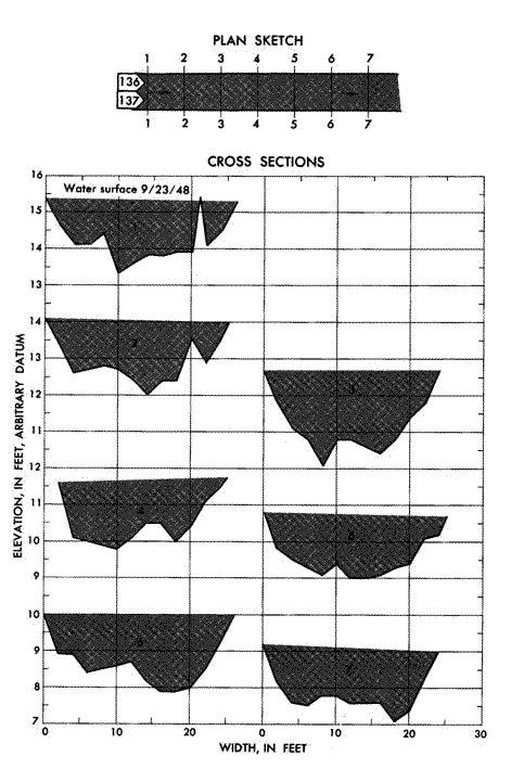 Plan and cross sections, Rock Creek Canal near Darby,
Montana.
Plan and cross sections, Rock Creek Canal near Darby,
Montana.
Site Photos
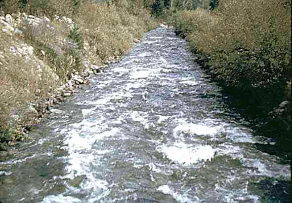 Photo 136: Downstream from above section 1, Rock Creek Canal near
Darby, Montana.
Photo 136: Downstream from above section 1, Rock Creek Canal near
Darby, Montana.
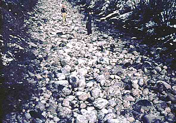
Photo 137: Downstream from above section 1, Rock Creek Canal
near Darby, Montana
Source: USGS with thanks |