|
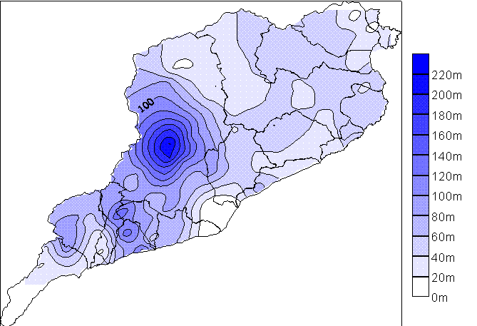
Fig. 1 Precipitation 10th June 2000 (mm)
Flash flooding occurred in the Barcelona area between 11 pm
local time of the 9th of June and 11 pm local time of the 10th of June 2000. The
maximum rainfall was recorded over the Llobregat basin, on the Montserrat
Mountain, with 224 mm, more than 80% recorded in less than 6 hours. The Vendrell
area had a maximum of 134 mm falling in less than 3 hours. This led to flooding
of tributaries of the Llobregat River and wadis that are normally dry.
Figure 1 (above) shows the cumulated rainfall distribution in
the Internal Basins of Catalonia for this period. This rainfall was produced by
a cold front that moved slowly from the SW to the NE, remaining stationary over
different places for two hours or more. The system, composed of different
convective cells, remained over the Tarragona basins between 12 pm and 3 am
local time, and over the mountains of the centre of Catalunya (mainly over the
Montserrat Mountain) between 4 am and 7 am local time.
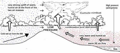
The meteorological analysis shows great convective instability
at low levels due to the presence of very wet and warm air, favoured by the
previous anticyclonic situation and warm advection from the Mediterranean. A
surface low to the north of Catalunya gave the necessary water vapour
convergence and triggered the first vertical movements, which were strengthened
by orographic factors. The flow of air from the SE that occurred over some
mountain ranges helped the vertical forcing. These conditions are simplified in
figure 2 below.
Figure 2: Simplified weather conditions for June 10th 2000
The conditions for further instability were set the previous
day when a cold depression from the NW had moved over the Iberian Peninsula
bringing very cold air to the medium and high troposphere overlapping the low on
the surface and producing very unstable conditions. Figure 3 below shows how at
an elevation of 1,200m (point A) the rising and cooling air mass (shown by the
DALR/SALR line) reaches the same temperature as the surrounding air (shown by
the ELR line) and above this height it is warmer and less dense. It will thus
rise freely.
Figure 3: Instability caused by the arrival of very cold air
at 1,200 m
The radiosounding ascents corroborated this situation; the
Convective Available Potential Energy was of 1866 J/kg (9 June, 12 am GMT) over
Palma de Mallorca (the Barcelona radiosounding did not arrived until 500 hPa due
to the strong wind). Values above 1500 J/kg indicate the high probability of
severe weather and heavy rainfall. Heavy rain and strong winds were produced
over Catalunya. The windstorm affected mainly the city of Barcelona.
The estimated damage was more than 65.000.000 Euros and 5
people were killed. However, this has not been the most catastrophic flood event
recorded in the lower part of the Llobregat basin. On September 20, 1971, 308 mm
were recorded in 24 hrs, with 19 deaths and damage estimated at $100 million. On
this occasion, the peak flow of the Llobregat River in Martorell (Montserrat)
was 3080 m3/s, more than twice the peak flow produced in the June 2000 event. On
September 25, 1962, 250 mm were recorded in 2 hours near the Llobregat basin
causing 441 deaths and 374 missing. The analysis of ancient archives since
the 14th century shows that catastrophic floods have affected this area once or
more each century, mainly in autumn. However, during the 17th, 18th and 19th
centuries, some catastrophic floods were recorded in spring.
Catalunya uses the SAIH (Sistema Automático de Información
Hidrológica) automatic flood warning system whose main goals are:
- To support the optimization of water resources both in the short and long
term;
- To support flood management, with advance knowledge of when and where floods
will occur and how extensive they will be.
The S.A.I.H. of the Internal Basins includes all the rivers
whose basins are completely in Catalunya (NE of the Iberian Peninsula). It is
managed by the Agencia Catalana de lAigua of Generalitat de Catalunya. 125
automatic rain gauges, more than 100 flow stations and 6 meteorological stations
have been installed in less than 17.000 km2.
With thanks to:
María del Carmen Llasat, Joan de Batlle, Tomeu Rigo y Mariano
Barriendos
Grupo de Análisis de Situaciones Meteorológicas Adversas (GAMA). Departamento
de Astronomía y Meteorología. Universidad de Barcelona. 08028 Barcelona |