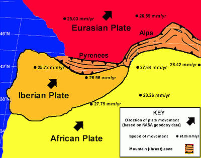
Topography of NE Spain showing estimated plate movements and
possible tectonic processes at work. Bathymetry is approximate.
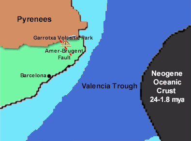 |
| Map showing simplified Africa-Iberian plate boundary zone in
the Barcelona region (after Alboran Project, 1999) |
Alkaline
volcanism has created Strombolian-type cones in the Garrotxa region over the
last 8 million years. This is associated with the thinning of the lithosphere
during crust extension and/or the migration of a convective hotspot. The western
Mediterranean region has undergone significant extension despite continuous
convergence of Africa and Eurasia since the Cretaceous. The most striking
evidence for this extension is the Neogene age of the oceanic crust beneath most
of the western Mediterranean. (See map showing simplified Africa-Iberian plate
boundary zone above).
 more more |
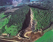
Croscat Volcano: La Garrotxa Volcanic Zone |
|
|
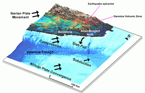
The Amer-Brugent fault system has well defined evidence of recent activity (Armijo
et al., 1988). An important earthquake occurred along the fault line in 1428 at
Queralbs with a maximum intensity of 9 on the Richter Scale. The Queralbs
epicentre is shown on the above diagram.
Present day seismicity is more moderate, in agreement with the
low deformation rate of the region. A more recent earthquake, also centred on
Queralbs, occurred on 21 September 2004 and registered 4.2 on the Richter scale.
An earthquake of this magnitude can be expected to occur in the region two or
three times in a decade. It was felt throughout the city of Barcelona, probably
because, like the 1428 earthquake, its focus was shallow (between 2 and 4
kilometres). Shallow-focus earthquakes tend to be larger and more damaging. This
is because they are closer to the surface where the rocks are stronger and build
up more strain energy.
The geology of Barcelona's site (mainly quaternary sands) helps
to accentuate an earthquake's effects. In most cases, shaking on sand is greater
than shaking on rock. In some situations a resonance can occur in deep sand
layers, markedly amplifying the shaking at certain frequencies. Liquefaction can
occur if shaking causes the transformation of loosely packed, water-saturated
sand, into a fluid mass. The sediments thus lose their strength and can no
longer support buildings which may then sink or lean.
The SERGISAI
project has made a GIS-based evaluation of earthquake hazard and risk
scenarios for the Barcelona urban area.
It is interesting to note that just before Barcelona was shaken
by the September 21 2004 earthquake, a 4.7 earthquake on the adjoining Eurasian
plate led to buildings in Kaliningrad on the Russian border with Poland being
evacuated. Geologists say that in this case, the tremors were caused by the
rising of the Scandinavian plateau, still recovering from the heavy ice sheet
that covered the region in the last Ice Age. The two earth tremors may be
connected since movements in one plate create new stresses elsewhere. Should
Barcelona's seismic risk be adjusted in the light of today's melting ice caps?
Key Mediterranean Tectonics Research Sources:
1. Alboran
project (1999)
2. Mediterranean
Tectonics: Carminati E. & Doglioni C. (2004)