|
Anticyclones
In contrast to depressions, anticyclones only involve one type of air mass
which usually cover large areas and do not have any fronts. They are high
pressure systems in which the air moves downwards towards the earth's surface.
As the air descends, the molecules become compressed, the pressure increases and
it warms. When air is warming, any moisture in the atmosphere is evaporated so
no clouds can form. The sky is clear. Anticyclones can be very large, typically
at least 3,000 km wide. Once they become established, they can give several days
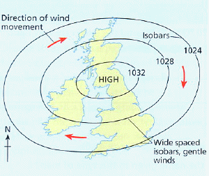
of settled weather. Winds are very gentle or even calm in an anticyclone, move
clockwise, and this is shown on a synoptic chart by wide spaced isobars.
British anticyclone weather
In Britain in summer an anticyclone will mean heatwaves during the day. At
night, however, as there are no clouds, heat will be quickly lost. The
ground will cool sufficiently to cause condensation of water vapour in the
descending warm air and mist or heavy dew may form. This will clear quickly in
the morning sun. After a few days, a layer of hot air builds up at ground level,
which eventually will give rise to thunderstorms, ending the anticyclone.
In winter the longer nights combined with clear skies leads to intense
cooling of the land. There is an increased risk of dew, frost and thicker, more
extensive fog patches which may be slow to clear or even persist.
Under very calm conditions, both frost and fog may persist for several days.
An anticyclone's very stable conditions and little air movement means that
pollution is trapped at low levels, resulting in very poor air quality such as
smogs.
|